Mapping Your Ancestor’s Land
In the pursuit of reconstructing our family’s past, we often delve deep into archival records, oral histories, and DNA analysis. However, one aspect that can profoundly enrich our understanding of our ancestors’ lives and connections is mapping the land on which they lived and worked, and perhaps even defended in war. The process of mapping your family’s land not only adds color to your genealogical research but also brings to light the geographical context that influenced their daily lives, occupations, migrations, and relationships with their neighbors, family members, and the broader community.
How to Start: Locating the Records
Embarking on the journey of mapping your family’s land begins with learning about surviving land records for your area. These can range from deeds, grant maps, homestead records, and property transfer documents to tax records and cadastral maps. Each piece of documentation offers a glimpse into the location, size, and sometimes even the value and usage of the land that your ancestors lived on. It is essential to approach these records with a critical eye, noting the legal descriptions, plot numbers, and geographical landmarks that can serve as anchors in your mapping endeavor. These original records are often housed in county record offices, but copies are often available in book form, on microfilm, or digitized online.
Once you have gathered the necessary records, the next step involves translating the often-arcane legal land descriptions into actual, mappable coordinates or areas. This process can be complex, involving understanding historical measurement units (such as rods, chains, and acres) and mapping techniques. However, modern tools and software have significantly simplified this task. Geographic Information System (GIS) software, for example, can be invaluable in plotting historical land parcels onto contemporary maps, allowing you to see the overlay of past and present.
Deeds are the most common record type that you will encounter. Depending on where your ancestor lived, the description of the land may be laid out differently. There are two main types of ways that land was partitioned out, and this was based on whether the state your ancestor lived in was a state land state, or a federal land state.
State land states vs. Federal land states
State land states included the original 13 colonies, states created from the original colonies, Hawaii, and Texas. Typically, the land was surveyed using the metes and bounds system, and is a bit more difficult in mapping than land in federal land states. The metes and bounds system is a surveying system that uses natural landmarks such as trees, rocks, streams, and neighbors property lines as points to outline the area of the land. Each point is then followed by a direction, degree, and length to the next point. An example of a metes and bounds land description looks like this:
Beginning on a post oak the North-East corner of an entry in the name of C C Vandiver (200 acres), thence West with his North boundary line one hundred and ninety one poles to a black oak with black gum and post oak pointers, thence North one hundred and forty poles to a white oak and red oak pointers, thence East one hundred and ninety one poles to a stake, thence South one hundred and forty poles to the beginning.
When transcribing a deed that uses a metes and bounds description, it is best to use a bulleted list so that you have a clear view of the description of the land. This will be particularly helpful when you are mapping out the land. You might summarize this example as follows:
- Beginning on a post oak on the NE corner of C C Vandiver’s entry, thence
- W 191p to a black oak with black gum and post oak pointers, thence
- N 140p to a white oak and red oak pointers, thence
- E 191p to a stake, thence
- S 140p to the beginning
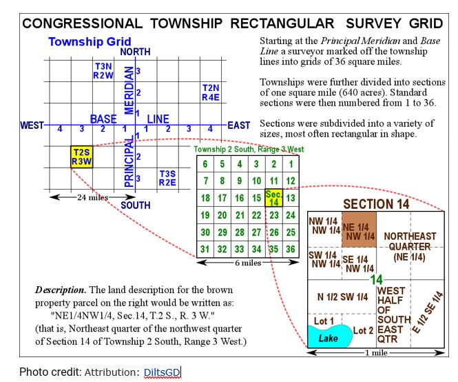
Federal land state land descriptions provide a simpler description to map out. It uses a grid like system that divides a county into townships. Each township was then divided into 36 one square mile sections. Each section was then divided into smaller pieces (usually quarters or halves). An example of a federal land description might look like this:
Lot number one of the North West quarter of Section seven in Township 37 of Range 3 East, containing 80 acres.
As with state land state descriptions, you may want to simplify the description for easier reading.
- Lot 1. The NW ¼ of S 7 in T 37, R 3 E
Locating Existing Maps
Historical maps can help you to map your family’s land. These maps, which can be found in local archives, libraries, or online digital collections, provide context that modern maps cannot. They reveal historical roadways, waterways, and landmarks that may have influenced your ancestors’ lives but no longer exist or have significantly changed. By overlaying these historical maps with your land plots, you can begin to visualize the physical context in which your ancestors lived. You can see how close they were to schools, churches, railways, and other important community hubs, offering insights into their daily lives and social networks.
The Library of Congress has a large collection of historical maps online. These can be particularly helpful when locating state land. Using maps for the area your ancestor lived, you can find waterways and roads that existed at the time that your ancestor lived there.
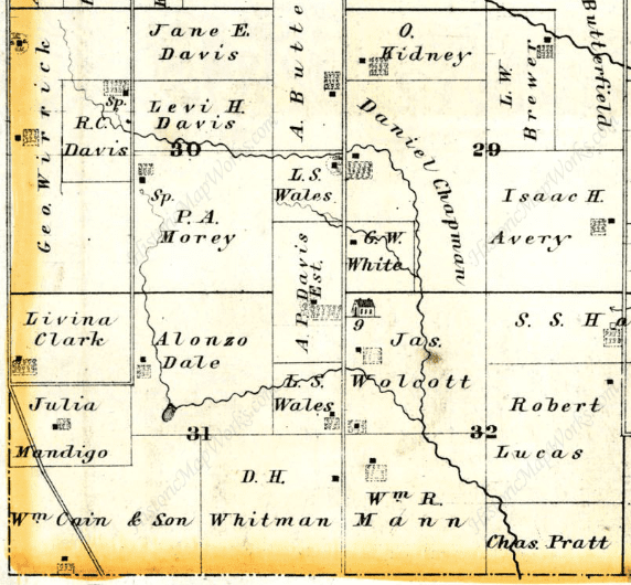
A great resource for mapping federal land are land ownership maps. Historic Map Works has a large collection of county land ownership maps. Most counties created these maps, mostly starting in the 1870s. Each book usually contains a county and is broken into townships. The townships will provide each section and the owner of that land for the year. If you get lucky, you may be able to locate your ancestors’ land on one of these maps. One of the great benefits of a land ownership map is that you can easily see who the neighbors are.
Mapping Software
There is a wide variety of mapping software that can help you create the outline of your ancestors’ plot of land. This is particularly helpful with state land as the shapes are not clean-cut squares or rectangles like federal land. Mapping software allows you to simply input each call and provides you with the shape of your ancestors’ land. These can be overlayed with current or historical maps, helping you piece together where the land is located on a current map.
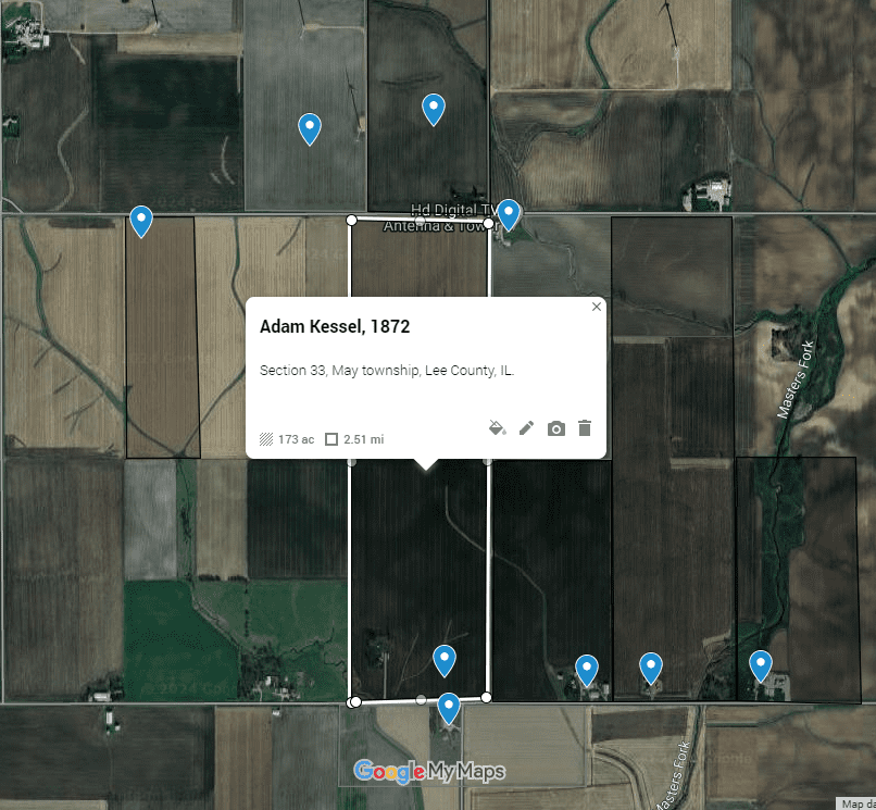
Mapping federal land is much easier and can be done without a mapping program. Google Maps has a tool called Earth Point where you input the state, principal meridian, township, range, and section, and it will take you to that section in Google Earth. You can then read your legal description and divide up the section until you pinpoint your ancestor’s portion. Once the land is located, you can create a custom map in Google Maps and use their tools to map the land and give it a label.
Conclusion
Mapping your family’s land opens the door to a new view that can be profoundly revealing. By mapping the landholdings of neighbors and relatives, you can uncover patterns of land inheritance, migration, economic status, and even social and familial networks that traditional records alone might not fully show. For example, discovering that families intermarried and exchanged land across generations can provide a deeper understanding of the social fabric and dynamics of the community in which your ancestors lived.
In the process of mapping, don’t overlook the narrative power of the maps you create. These maps serve as compelling visual stories of your ancestors’ connection to the land and their community. They can be shared with family members to help them visualize their heritage or used as illustrative tools in family histories, presentations, or publications.
Mapping your family’s land is a journey that can transform your understanding of your ancestors’ lives. It bridges the gap between the abstract details in textual records and the physical reality of the land they lived on. This endeavor requires patience and a bit of detective work, but the rewards are immeasurable. Not only does it enrich your genealogical research with a tangible connection to the past, but it also provides a unique and powerful way to tell your family’s story through the lens of the land they called home.
If you need help finding your ancestor’s land as well as mapping it, contact Lineages. We have many resources and excellent researchers who are eager to help.
By Tyler
Resources:
FamilySearch Wiki, “United States Land and Property” https://www.familysearch.org/en/wiki/United_States_Land_and_Property
Bureau of Land Management General Office Records https://glorecords.blm.gov/search/default.aspx
EarthPoint https://www.earthpoint.us/TownshipsSearchByDescription.aspx
Historic Map Works https://historicmapworks.com/
Library of Congress Map Collections https://www.loc.gov/maps/collections/